Data
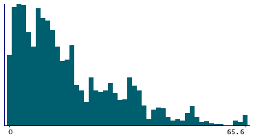
21,180 items of data are available, covering 21,180 participants.
| Maximum | 65.6 |
| Decile 9 | 35.8 |
| Decile 8 | 28.1 |
| Decile 7 | 20.7 |
| Decile 6 | 15.9 |
| Median | 12.3 |
| Decile 4 | 9.7 |
| Decile 3 | 7.4 |
| Decile 2 | 4.2 |
| Decile 1 | 2.2 |
| Minimum | 0 |
|

|
- Mean = 16.3514
- Std.dev = 13.7631
|
Notes
The purpose of this domain is to illustrate the deprivation as a result of a household's inability to access a range of services, considered necessary for day-to-day living. The access is by walking or using public bus services or both. The indicators used for the geographical access to services domain were:
- Food shop
- GP surgery
- Primary school
- Post office
- Public library
- Leisure centre
- NHS dentist
- Secondary school
- Transport nodes
0 Related Data-Fields
There are no related data-fields


